America’s National Park Service runs more than 415 sites, including national seashores, recreation areas, historical sites, and national parks. Collectively, these sites receive close to 85 million visitors a year—with more than 11 million of them heading to just one national park in particular (Great Smoky Mountains).
Short of visiting in winter and hiking deep into the backcountry, the parks’ popularity can make it tricky to find your own slice of solitude. Tricky, but not impossible. Here are 10 scenic spots you can have all to yourself inside the country’s most-visited national parks.
Editor’s note: Due to COVID-19 concerns, national parks may have limited hours and amenities. Check the NPS website for the most up-to-date information before traveling.
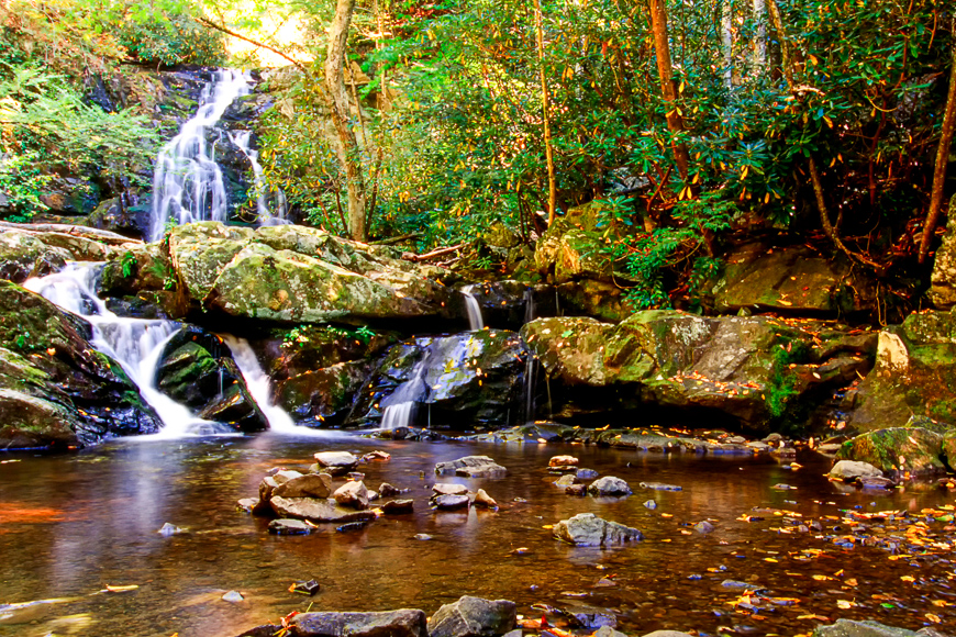
Spruce Flats Falls, Great Smoky Mountains National Park
Great Smoky Mountains National Park sees more than 11 million visitors each year now. That’s more than the Grand Canyon and Yosemite combined. But given that the majority of those visitors saw the park from the scenic highway that winds its way through the mountains, you’ll have an easier time finding your own area of the park if you’re willing to get out of the car.
More than 800 miles of hiking trails carve their way through Great Smoky Mountains National Park, which sprawls across North Carolina and Tennessee. One of the best secret gems is the short, moderately steep trail to the hidden Spruce Flats Falls. The trail, not shown on most park maps, begins behind the Great Smoky Mountains Institute at Tremont. After parking at the visitor center, head up the gravel path that leads toward the staff housing area. When the trail splits, head right and make your way downhill to the base of the falls. You may pass school groups, but the quick two-mile round-trip hike is worth it to see the nearly 30-foot multi-tiered waterfall.
Toroweap Overlook, Grand Canyon National Park
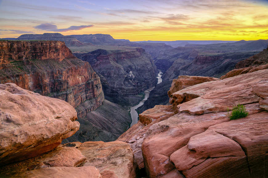
Over 6 million people visit Grand Canyon National Park each year presently. About 90 percent of them head to the South Rim, while the remaining few drive the extra distance to the North Rim. But just because you head north doesn’t mean you’re out of the woods (or crowds) yet. Finding a secret slice of Grand Canyon National Park requires you to think beyond the developed rims.
One of the best spots, kept secret mostly because it requires navigating 60 miles of the unpaved Country Road # 109 and has no services, is the Toroweap Overlook. Located in the northwest of the park, abutting the just-as-remote Grand Canyon-Parashant National Monument, the Toroweap Overlook (also known as Tuweep) offers visitors to the primitive area views of one of the narrowest and deepest portions of the inner canyon. In addition to the Colorado River 3,000 feet below, you’ll see remnants from the area’s volcanic activity.
A high-clearance vehicle is must for the last three miles, and it’s worth booking one of the nine campsites (available by permit) so you can take in the view at sunrise and sunset while still having time to explore the area’s two hiking trails.
Artist Point, Yosemite National Park
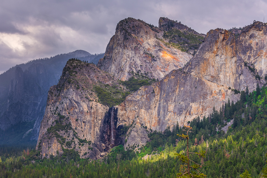
While nearly 4 million visitors come to Yosemite National Park each year, most of them never leave Yosemite Valley. Granted, the seven-mile-long canyon—carved from a river and later enlarged by glaciers—is worth the visit because of its views of Half Dome and Yosemite Falls. But the real beauty of Yosemite National Park lies in the acres of unspoiled nature it preserves.
Let the hordes of tourists unload for a quick photo op at Tunnel View. You can use this as your parking area to reach the just-as-spectacular view at Artist Point. The trailhead starts on the uphill side of the road. You’ll walk along the Pohono Trail for about a half-mile before hanging left when it meets up with the old stagecoach road that leads into Yosemite Valley. After another half mile, you’ll know you’ve arrived when you hear yourself inhaling deeply. Return the same way you came.
Point Sublime, Yellowstone National Park
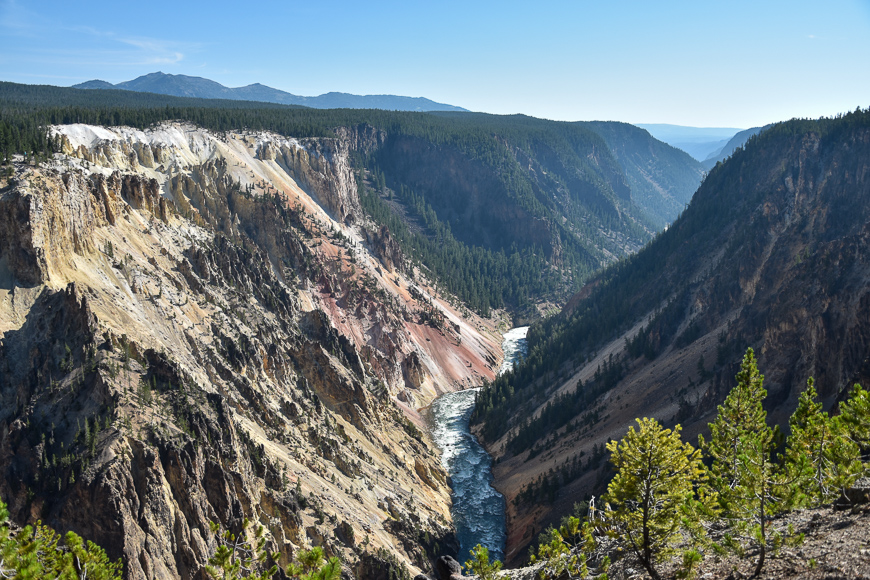
The world’s first national park attracts just over 4 million annual visitors, many of which unload from tour buses, wait on Old Faithful, and depart shortly thereafter. Depending on your crowd tolerance, it may feel like there are 4 million people sitting right around the geyser at any given point. But with more than 2.2 million acres and over 900 miles of hiking trails, Yellowstone National Park holds a ton of hidden-in-plain-sight trails that remains relatively unused despite their easy access.
Travel just over half a mile on the South Rim Trail before heading the additional half-mile to Point Sublime. You’ll arguably have better, more expansive views of the yellowy, pink, and orange-striped canyon, the Yellowstone River, and the Lower Falls than you can find at any of the made-for-car viewpoints.
Whatever you do at Yellowstone, as long as you get out of the car and head away from the roads, you’ll likely find wildlife, aquamarine pools, mud pots, and waterfalls that the majority of park visitors didn’t even know existed.
Lulu City, Rocky Mountain National Park
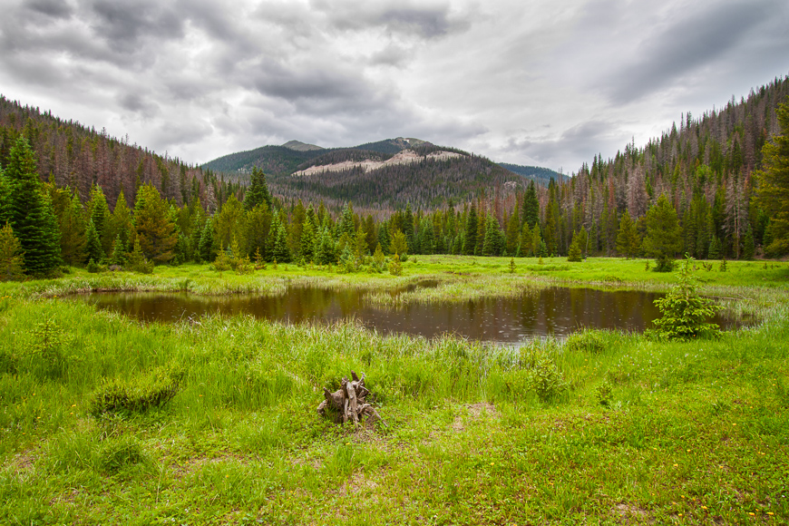
Of the hundreds of trails available to hikers, most visitors to Rocky Mountain National Park opt for summit hikes (the park has 60 peaks that tower more than 12,000 feet) or trails that lead to lakes or waterfalls. The trail to Lulu City doesn’t lead to any of these, but it gets bonus points for taking you to the site of a late 1880s mining camp.
You can find the ghost town by starting at the Colorado River Trailhead. You’ll parallel the river and, if you’re looking, will spot tailings from the Shipler Mine about two miles into the hike. Pass by meadows before reaching remains of cabins and old building foundations on this fairly easy 3.7-mile one-way trail.
To extend your hike and see Little Yellowstone (the park’s miniature version of the Grand Canyon of the Yellowstone), stay right when you come to the fork for Lulu City. Once you’re at the canyon, follow the Grand Ditch until you meet the stage road that will take you to Lulu City for a total loop of nearly 14 miles.
Beach 1 and Beach 2, Olympic National Park
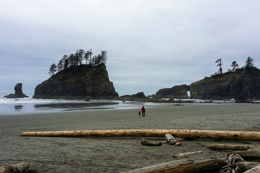
Most visitors stick to the rainforest and mountains—Hoh Rainforest, Hurricane Ridge, Lake Quinault—when they visit the Olympic National Park. Those that do opt to visit the coast usually head to well-known beaches like Kalaloch, Ruby, and Shi Shi. All of these places have, indeed, earned their reputation and demand a visit. But for your own strip of sand with easy access that doesn’t require a miles-long trek, pay a visit to Beach 1 and Beach 2 before Kalaloch when heading north on Highway 101, or Beach 3 and Beach 4 after Kalaloch (but before Ruby Beach).
Don’t confuse these with First, second, and third beaches near The Forks, unless you want to hang out with rabid Twilight fans. Look carefully on the right side of the road for small pullouts where you can park. Some may mark which beach you’re at, but it’s easy to drive past. Short trails through the woods open up to vast expanses of some of the most beautiful stretches of coastline in Washington (and sandier than some of their more famous counterparts). As with any coastal visit, check the tides beforehand, look for any signs marking overland trails, and watch for high waves that make the tree trunks scattering the beach quite dangerous.
Kolob Canyon and Terrace, Zion National Park
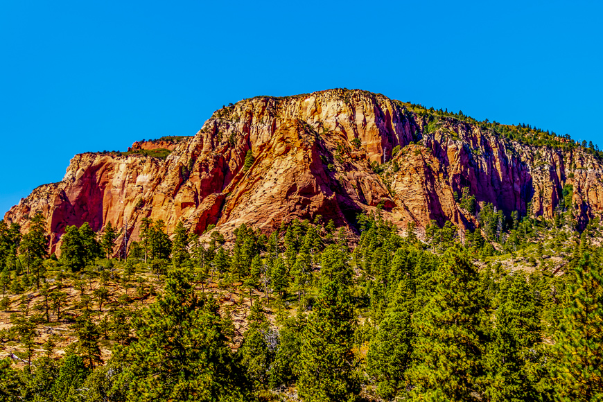
Most visitors to Zion National Park come for the natural wonders as seen from popular hikes like Angel’s Landing, the Narrows, and even the lesser-known (because it’s so hard to get a permit) Subway. But if you’re not most visitors, consider adding a visit to one of the park’s other areas, the Kolob Canyons and Kolob Terrace. Both areas are entirely separate from the Zion Canyon Scenic Drive and offer their own trails and sights.
Many of the trails in the northern area of the park are considered Wilderness and do require a permit and have group-size restrictions, however, the Timber Creek Overlook Trail is an easy, quick stroll with a gorgeous viewpoint, just off of Kolob Canyons Road (no restrictions). The Middle Fork of Taylor Creek Trail is a popular route in the area, but you can explore further and see “finger canyons” by doing the day-hike, North Fork (total of nine miles if combined with Middle Fork) or the shorter, South Fork of Taylor Creek route (two miles).
Kolob Terrace Road, which cuts through the Lower and Upper Kolob Plateau, is an uncrowded, leisurely drive that you can take that’s outside of the main canyon. This is where the infamous “Subway” is located; the trail is officially named Left Fork of North Creek and the top-down route is Russell Gulch. However, there are plenty of other less-technical and easier-to-access hikes to do in the area, like Hop Valley Trail, Grapevine Trail, and Northgate Peaks Trail.
Bradley Lake, Grand Teton National Park
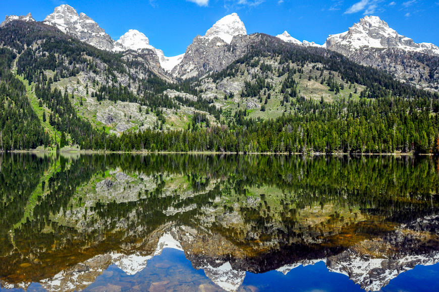
Fortunately for visitors to the Grand Tetons, Grand Teton National Park sits below Yellowstone, drastically reducing the number of people that actually stop. For a relatively flat hike leading to iconic Teton scenery, head to Bradley Lake. You can opt to start from the Lupine Meadows Trailhead or the Taggart Lake Trailhead. From either trail, there are multiple paths that stray off, so it’s easy to get lost. But the beauty in this is if you have a map, you can make it to Bradley Lake and shake off some of the other hikers—if there are any.
From the Taggart Lake Trailhead, you can make this into about a six-mile loop hike or opt to go a bit further and look for the Avalanche Canyon trail. Unmarked on maps, enough people travel this trail that it’s fairly noticeable, despite debris from avalanches sometimes blocking portions of the path. Look for the trail on the north shore of Lake Taggart. As you move up the canyon, cairns mark the path that eventually leads to Lake Taminah. However, if you’ve made it that far, you have (hopefully) planned for an overnight trip and have bear canisters—this is grizzly country, after all.
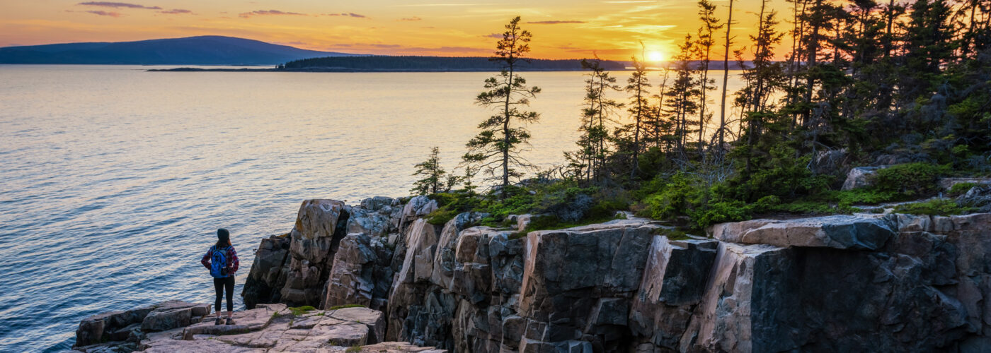
Schoodic Point, Acadia National Park
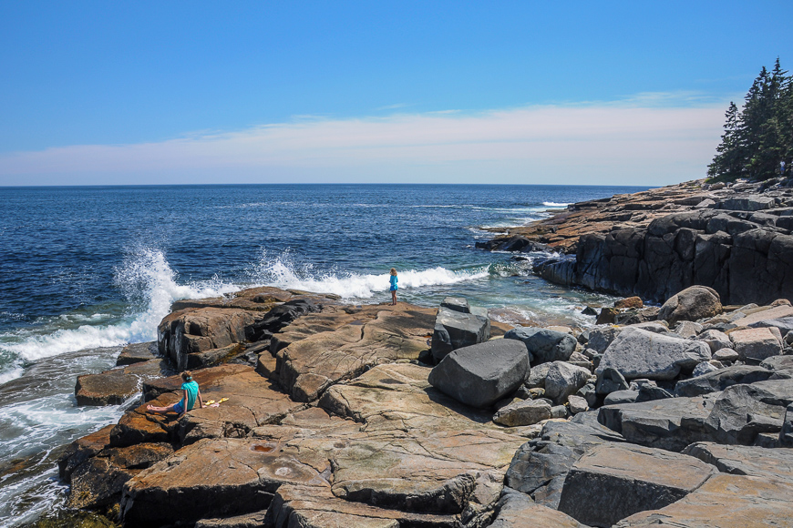
Most people associate a visit to Acadia National Park with a visit to Mount Desert Island. But even though the majority of the park is located there, opt to visit the only section of the park that’s connected to the mainland. The Schoodic Peninsula, in particular Schoodic Point at the peninsula’s tip, offers quintessential views of waves throwing a salty spray into the air as they crash against granite cliffs.
The park also includes several islands, many favored by birds for nesting, including Little Moose Island, visible from Schoodic Point. Rent a kayak to paddle there, or access it by foot at low tide (just make sure you head out before the tide turns). Paddling to the Porcupine islands—off the coast of Bar Harbor—is another great option.
Bowman Lake, Glacier National Park
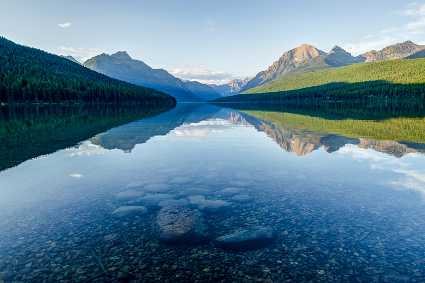
Glacier National Park’s Going-to-the-Sun Road is considered by many to be one of the world’s most spectacular drives. But off this road (the main highway through Glacier National park) you can find one of the most remote sections of the park: Bowman Lake.
Don’t get discouraged based on the long trek down pothole-laced roads. The ride is worth it, with a campground at one end of the eight-mile lake and a backcountry campsite at the other. Use the spot as a launching point for day hikes like the Numa Ridge Lookout trail that leads to a fire watch cabin and views of several area peaks and lakes. Or just use the off-the-beaten-path location as an excuse to zen out.
But perhaps the biggest secret of Glacier National Park is to visit now: Fewer than 25 of the park’s 150 glaciers remain, with the lingering glaciers expected to permanently disappear by 2030.
More from SmarterTravel:
- 10 National Parks That Are Better in Winter
- 10 Unforgettable Places to Sleep in National Parks
- The Best Places to Stargaze: 8 Dark-Sky Reserves and Sanctuaries
Editor’s note: This story was originally published in 2015. It has been updated to reflect the most current information. Ashley Rossi contributed to this story.
We hand-pick everything we recommend and select items through testing and reviews. Some products are sent to us free of charge with no incentive to offer a favorable review. We offer our unbiased opinions and do not accept compensation to review products. All items are in stock and prices are accurate at the time of publication. If you buy something through our links, we may earn a commission.
Top Fares From


Today's Top Travel Deals
Brought to you by ShermansTravel
France: 8-Night Paris, Avignon & Nice...
Infinity Worldwide Vacations
 vacation
$2880+
vacation
$2880+
Poconos: 3 Nts in Garden of...
ResortsAndLodges.com
 hotel
$305+
hotel
$305+
7-Nt Canada & New England Cruise,...
Princess Cruises
 cruise
$839+
cruise
$839+